


Jameson Precinct, Koochiching County, Minnesota
About
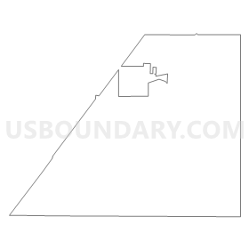
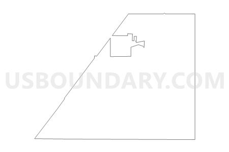
Outline
Summary
| Unique Area Identifier | 602803 |
| Name | Jameson Precinct |
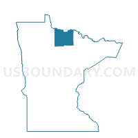
| County | Koochiching County |
| State | Minnesota |
| Area (square miles) | 31.93 |
| Land Area (square miles) | 31.87 |
| Water Area (square miles) | 0.07 |
| % of Land Area | 99.79 |
| % of Water Area | 0.21 |
| Latitude of the Internal Point | 48.37131780 |
| Longtitude of the Internal Point | -93.53281960 |
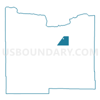
Maps

Graphs
Select a template below for downloading or customizing gragh for Jameson Precinct, Koochiching County, Minnesota


Neighbors
Neighoring Voting District (by Name) Neighboring Voting District on the Map
- Cingmars Precinct, Koochiching County, MN
- Cross River-Dentaybow Precinct, Koochiching County, MN
- Littlefork Voting District, Koochiching County, MN
- Meadowbrook Precinct, Koochiching County, MN
- Rat Root Precinct, Koochiching County, MN
- Scarlett Precinct, Koochiching County, MN
- West Koochiching Voting District, Koochiching County, MN
Top 10 Neighboring County Subdivision (by Population) Neighboring County Subdivision on the Map
- Rainy Lake UT, Koochiching County, MN (4,048)
- Littlefork city, Koochiching County, MN (647)
- East Koochiching UT, Koochiching County, MN (355)
Top 10 Neighboring Place (by Population) Neighboring Place on the Map
Top 10 Neighboring Unified School District (by Population) Neighboring Unified School District on the Map
- International Falls Public School District, MN (10,163)
- Littlefork-Big Falls School District, MN (1,659)